A quick note: my name is Mike Romero, and I'm a Historic Interpreter at Colonial Williamsburg. The postings I make on this site are my own personal opinions and research, and do not necessarily reflect the views of Colonial Williamsburg. With that said, enjoy the read!
 |
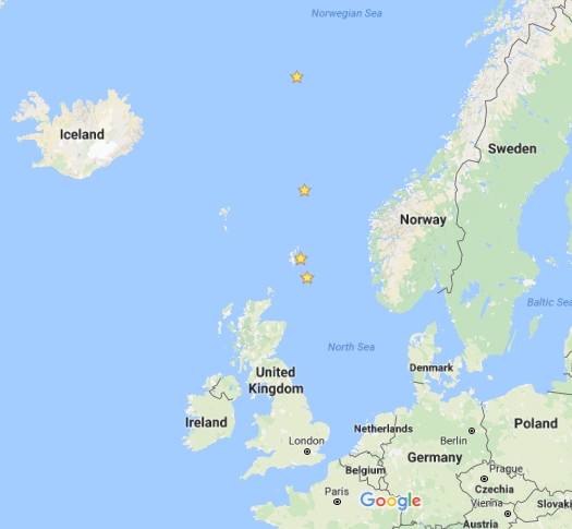
Track of the Racehorse and Carcass with
position plots for June 13, 15, 17 and 20, 1773. |
After weighing anchor from the Nore on June 4th, the converted bomb vessels
Racehorse and
Carcass under the command of Captain Constantine Phipps crosses the North Sea and proceeds well into the Norwegian Sea as the month progresses. By June 20th, the expedition is already north of Iceland. While they have yet to reach any ice, Phipps takes multiple opportunities of testing various mathematical instruments and navigational tools. I've included six of Phipps' journal entries from mid to late June for us to examine this time around.
"12th. The wind at SE, and the ship well advanced, I ordered the allowance of liquor to be altered, serving the ship's company one-fourth of their allowance in beer, and the other three-fourths in brandy; by which means the beer was made to last the whole voyage, and the water considerably saved. One half of this allowance was served immediately after dinner, and the other half in the evening. It was now light enough all night to read upon deck."
According to the Regulations and Instructions in force in 1772, seamen were allotted a gallon of beer each day. If beer is unavailable, other spiritous liquors may be substituted in different proportions; half a pint of brandy being equal to a gallon of beer. Spirits were often diluted with water (4 parts water to 1 part spirits was the precedent set by Edward "Old Grog" Vernon in the early 1740's) in open view of the assembled crew on deck. Based on the Phipps' journal for June 12th, it seems the men are now receiving a quart of beer and five cups of brandy grog each day. The beer was likely "small beer" of the time, known for low alcohol content with a comparatively high caloric value. It's no wonder Phipps wanted to preserve his supply, considering the trials of the voyage to come in later months.
 |
A chart from the 1772 edition of Regulations and Instructions Relating to His Majesty's Service at Sea
detailing the provisions allotted to Royal Navy seamen each day. |
"13th. The weather still fine, but considerably less wind than the day before, and in the afternoon more Northerly. The longitude at ten in the morning was found by my watch 0°6' W. We took three observations of the moon and sun for the longitude; the extremes differed from one another near two degrees: the mean of the three gave the longitude 1°37' E. At noon the latitude observed was 59°32'31". We found a difference of 36' between the latitude by dead reckoning and observation, the ship being so much more Northerly than the reckoning. The distance by this log was too short by forty-three miles. A log marked forty-five feet, according to the old method, would have agreed with the observation within two miles in the two days' run. The circumstance of steering upon a meridian, which afforded me such frequent opportunities of detecting the errors of the log, induced me to observe with care the comparative accuracy of the different methods of dividing the line, recommended by mathematicians, or practised by seamen. In the afternoon I went on board the
Carcass to compare the time-keepers by my watch. At six in the evening the longitude by my watch 0°4' E. This evening, the sun set at twenty-four minutes past nine, and bore about NNW by the compass. The clouds made a beautiful appearance long after to the Northward, from the reflection of the sun below the horizon. It was quite light all night: the
Carcass made the signal for seeing the land in the evening."
The various logs referred to here are variants of the chip log, a tool used to measure the approximate speed of a ship through the water by counting knots in a measured line. The distances between knots varied depending on the type of glass being used to measure time; a log with 51 feet between knots in the line was commonly used with a 30 second glass, for example. See the British Tars article
"The Tools Needed for Dead Reckoning" for more information on this and other navigational tools. Incidentally, it was this article that led to me beginning to interpret naval history in earnest, so a quick thank you to blogger Kyle Dalton for getting me started on this journey!
"15th. By an observation at eight in the morning, the longitude of the ship was by the watch 0°39' W: Dip 74°52'. At half past ten in the morning, the longitude, from several observations of the sun and moon was 0°17'W; at noon being in latitude 60°19'8", by observation, I took the distance between two ships by the Megameter; and from that base determined the position of Hangcliff, which had never before been ascertained, though it is a very remarkable point, and frequently made by ships. According to these observations it is in latitude 60°9' and longitude 0°56'30" W. In the Appendix I shall give an account of the manner of taking surveys by this instrument, which I believe never to have been published before. At one, observed the dip to be 75°. A thick fog came on in the afternoon, with a flat calm; we could not see the
Carcass, but heard her answer the signals for keeping company. Variation, from the mean of several observations, 25°1' W."
The Megameter was an instrument constructed on similar principles to the object-glass Micrometer, and was suitable only for measuring distances less than 10°. A 1772 treatise by M de Charnieres endeavored to making determining longitude with assistance from the Megameter into more common practice.
"17th. Wind fair, and blowing fresh at SSW, continued the course NNE: ordered the people a part of the additional clothing: saw an English sloop, but had no opportunity of sending letters on board, the sea running high. At ten in the morning, longitude by the watch 0°19'45" W: at noon, the latitude observed was 62°59'27". The ship had out-run the reckoning eleven miles. I tried Bouguer's log twice this day, and found it give more than the common log. Variation 19°22' W."
Meteorological Data:
6/17 Weather on Expedition: 52° F, winds from the SSW, cloudy at noon.
6/17 Weather in Edgewater, MD (Where the blogger was travelling with family; details from Weather Channel app.): Forecast high was 93° F, mostly sunny and humid.
 |
The blogger takes a shot at explaining how Captain Phipps
determined his latitude above the equator using
a midnight sighting of the sun. |
"19th. Wind to the NW. Took the meridian observation at midnight for the first time: the sun's lower limb 0°37'30" above the horizon; from which the latitude was found 66°54'39" N: at four in the afternoon, longitude by the watch 0°58'45" W: at six the variation 19°11' W."
"20th. Almost calm all day. The water being perfectly smooth, I took this opportunity of trying to get soundings at much greater depths than I believe had ever been attempted before. I sounded with a very heavy lead the depth of 780 fathom, without getting ground; and by a thermometer invented by lord Charles Cavendish for this purpose, found the temperature of the water at that depth to be 26° of Fahrenheit's thermometer; the temperature of the air being 48°1/2.
We began this day to make use of Doctor Irving's apparatus for distilling fresh water from the sea; repeated trials gave us the most satisfactory proof of its utility: the water produced from it was perfectly free from salt, and wholesome, being used for boiling the ship's provisions; which convenience would alone be a desirable object in all voyages, independent of the benefit of so useful a resource in case of distress for water. The quantity produced every day varied from accidental circumstances, but was generally from thirty-four to forty gallons, without any great addition of fuel. Twice indeed the quantity produced was only twenty-three gallons on each distillation; this amounts to more than a quart for each man, which, though not a plentiful allowance, is much more than what is necessary for subsistence. In cases of real necessity I have no reason to doubt that a much greater quantity might be produced without an inconvenient expence of fuel."
Water was not officially included in a seaman's provisions at this time, though ships would generally take on enough water to last half as long as other provisions. Water was generally available from scuttlebutts on deck; a seaman could drink his fill at the scuttlebutt, though a marine sentry stood guard to ensure that no water was taken away. In times of shortage, or when a ship was far from a source of replenishment, water was rationed jealously. Being able to distill fresh water from the sea in any quantity could be a great boon to naval vessels if the method was indeed practical.
Meteorological Data:
6/20 Weather on Expedition: 48.5° F, calm and cloudy at noon.
6/20 Weather in Williamsburg (According to Weather Channel.): 77° F, 76% humidity, overcast at 1:00 PM.
The summer isn't too far advanced for either Phipps or myself, though depending on the day, we're both starting to experience uncomfortable temperatures or weather and taking steps to compensate. For Phipps, that means breaking out additional winter clothing on June 17. For me, that means filling my cannikin with gatorade for my first quart of fluids each day. We're still only getting started, so stay tuned!
Sources:
1. Phipps, Constantine John.
A Voyage Towards the North Pole Undertaken at His Majesty's Command. (J. Nourse, 1773.)
2. His Majesty in Council.
Regulations and Instructions Relating to His Majesty's Service at Sea, The Eleventh Edition. (1772.)
3. McDonald, Janet.
Feeding Nelson's Navy: The True Story of Food at Sea in the Georgian Era. (Frontline Books, 2014.)